Sights in Brest
The Brest Fortress is a monument of the defence architicture which was erected in the middle of the 19th century and is located to the West of Brest. It was built on the former sight of the ancient settlement on the islands which are formed by the rivers the Western
 Bug and the Mukhavets and the artificial canals. This place was chosen for the building of the Brest Fortress because of the very important military strategic position of Brest-Litovsk as Brest was called at that period of time. It was a military engineer Delovan who suggested the building of this fortification just on the junction of the rivers the Western Bug and Mukhavets in 1799. The project was worked out by Russian military building engineers K. Opermann, Maletzki and A. Feldmann and was adopted in 1830. The construction of 4 fortifications began. The central part, the Citadel, was built at the very place where the trade craftsman centre of the town was, and with the beginning of the construction it was moved out to the right branch of the Mukhavets.
 The Volyn(Southern) fortification was being built at very place where the Brest Castle was. And the Brest Castle was pulled down in the period of the construction of the Volyn fortification.
The Kobryn(Nothern) fortification was being built at the place of the Kobryn district of Brest where there were lots of the city building, private houses.
The Terespol(Western) fortification was being built on the Western branch of the Western Bug. On this territory there were many churches, monasteries, cathedrals. Some of them were reconstructed others adjusted for the needs of the Fortress garrison.
The reconstruction was in the peroid since 1833 till 1842. The first stone of the Fortress was laid on 1.06.1836. And it was put into action in 1842. The total area of all the fortifications is 4 sq. km. The lenght of the defence line is 6,4 km.
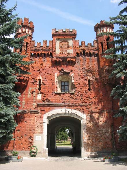
The most protected defence part was the Citadel, which consisted of two storey and about two km long barracks in a form of a curved exclusive circle. Its walls are about 2 meters thick. And its 500 casemates could accommodate 12 thousand people with all necessary ammunition and supply of food for the dafence. The recesses of the barracks walls with loopholes and gun-ports were adjusted for a gun and rifle firing. The compositional centre of the Citadel was St. Nikolas Church(1856-1879, architect Grimm), which was built on the highest part of the Central Island.
The Citadel was connected with the other three fortification with the help of the gates and bridges. It was connected with the Kobryn fortification with the help of Brest and Brighit gates and bridges across the Mukhavets, with the Terespol fortification - with the help of Terespol gate and the biggest cable bridge across the Western Bug, with the Volyn fortification - Kholmski gate and drawbridge across the Mukhavets. The Kholmski and Terespol gates are partially preserved.
Terespol, Kobrin and Volyn fortifications protected the Citadel. The external defence line of the fortress was 10 metre high earth work ramparts with brick casemates. In front of them there were canals with bridges over them which were directed outside the fortress.
At the beginning of its existence the Brest Fortress was one of the most perfect fortifications in Russian. In 1878-1888 there were built 10 forts more around the Brest Fortress. After that the defence line achieved 30 km long.
The second reconstruction took place in 1911-1914 as a result of which the whole defence line was improved. The second line of the forts was built. At a distance of 6-7 km from the Brest Fortress. But the construction and reconstruction of the forts of the Brest
 Fortress hadn't been completed by the beginning of the World War I. In August of 1915 the Russian headquarters evacuated the garrison of the Fortress in order to avoid the surroundind of it. Some of the fortifications were exploded by the Russians.
 The Brest Fortress is known for the signing of the Brest Peace Treaty in 1918 in the White Palace.
According to Riga Peace Treaty (1921) the territory of the Brest Fortress as well as the territory of the Western part of Belarus became a part of Poland.
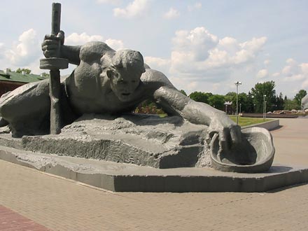
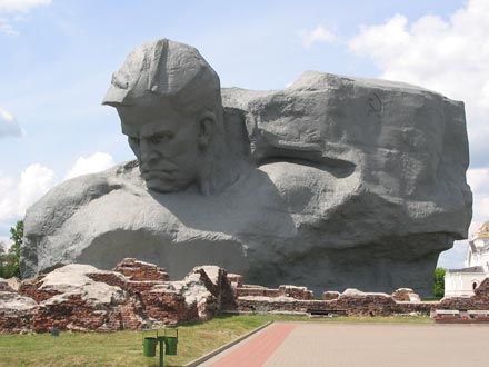
In september 1939 when the fascists Germany attacked Poland a part of the Citadel of the Brest Fortress was ruined, the buildings of White Palace and Engineering administration were damaged. With the increased mobility and technical modernisation of military forces the Brest Fortress lost its military defence value. It was used for quartering troops of the Red Army units 22.06.1941 the Garrison of the Fortress was the first to repulse the attack of the fascists.
Belavezhskaya Pushcha National Park
It is situated in the west of the republic within Grodno and Brest regions and occupies the territory of 87.36 thousand hectares. The administrative centre is situated in Kamenyuki settlement Kamenets district at a distance of 60 kms from Brest. 20 kms from
 Belavezhskaya Pushcha the town of Kamenets is located, it was founded by Prince Vladimir Volynski in the 13th century, a watch-tower (Belaya Vezha) rises above there and the name of Belavezhskaya Pushcha comes probably from this name. In the centre of the pushcha there is a small village Viskuli, where an attractive palace was built in 50-s and which served the leaders of the former USSR and now Belarus for the residence. In 1991 the famous "Belavezha" agreement about independent republics dropping out from the USSR was signed here and Viskuli got the world fame.
 A wide reputation to the pushcha is given by: the only availability of the last remains of vast in 13th century European forests with the presence of relic plants and animals populations (aurochs, first of all); diversity and riches of biogeocenoses and ecosystems on a comparatively small territory with homogeneous geologic texture and the climate similar to that of the Central Europe (the average annual temperature is +6.6 C).
In immediate proximaty to the borders of Belavezha forest tract there is a watershed of the Baltic and the Black seas. The Narev river springs from beyond the borders of the pushcha, crosses the Dikoye marsh, then the northern part of the pushcha from east to west and has swamped narrow flood-lands. Its main tributary is the Narev. The river Pravaya Lesnaya which basin is separated from the one of the Narev by Belavezha ridge, springs from the territory of Poland, runs to the south-eastern direction and crosses the southern border of the pushcha. There it interflows with the Levaya Lesnaya making up the Lesnaya river which falls into the Bug northward of Brest. The Narev, Narevka and Pravaya Lesnaya take a number of small rivers and brooks, such as Gvozna, Solomenka, Pererovnisa, Perevoloka and others which river-heads are situated within the pushcha.
There are no natural lakes on the territory of the pushcha. The largest of ten artificial ponds have been created in the flood-lands of the Perevoloka river (the lake Lyadskoye - 345 hectares and the lake Khmelevskoye 75 hectares), where great numbers of waterfowls stop during their flights.
 The flora of the pushcha are represented by 900 species of vascular cryptogamous and seminal plants, which make up 64% of specific composition of plants that grow on the territory of the Republic. About 10% of species are arboreous suckers, among which there are 25 species of trees, 35 of shrubs and suffrutices, 12 species of dwarf shrubs.
 Conifers are represented by Scotch pine and Common Spruce as well as by Silver Fir, rare in this region.
About 260 species of mosses, more than 290 species of lichenes and 570 of fungi grow in the pushcha.
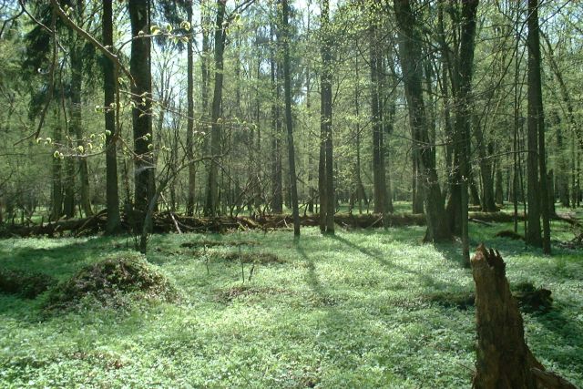
Belavezha forests are distinguished by the presence of lots of virgin forests. They are mainly (more than a half) represented by old-aged standing trees (100-200 years old), which have formed and developed in comparatively natural conditions. There are 250-350-year old lots, several trees at the age of 300-600 have preserved here. Conifer woods make up 68.8% of the forest-covered area and mainly are represented by pine (58.0%) and spruce forests (10.7%).
There are 5.8% of broad-leaved forests in the pushcha and approximately as much again there are narrow-leaved ones. Root deciduous marsh forests are spread there (18.7%). Moss and grass marshes occupy the area of 3.16 thousand hectares. Marshes as the regulators of gas composition of atmosphere and hydrologic regimen play an important part in keeping up the stability of Belavezhskaya Pushcha ecosystems and in preserving its biodiversity.
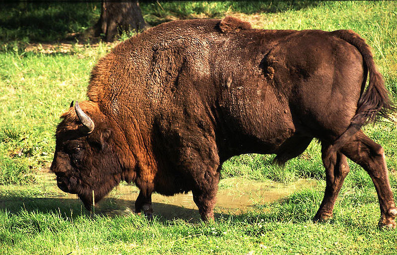
The fauna of the pushcha number more than 10 thousand species. More than 59 species of mammals dwell here including the biggest representative of the modern European fauna aurochs. Rodents are
 the most numerous, there are more than 20 species of them. The most remarkable among them is beaver. Out of carnivores wolf ,fox, lynx, pine marten dwell in the pushcha. Big ungulates such as wild boar, red deer, roe and elk are animals for hunting and their total number is optimised. Aurochs also used to be a species for hunting in its past, but it hat been completely exterminated by 1919. The biotechnical measures that had been carried out let re-establish the head of livestock and led the number of aurochses up to 300 in the pushcha.
 227 species of birds are taken stock of in Belavezhskaya Pushcha, 40 of them are put in the Red Book of the Republic of Belarus. The herpetofauna number 11 species of amphibious and 7 species of reptiles. 24 fishes dwell in reservoirs. The most numerous is pike, roach, tench, ruff and perch. Belavezhskaya Pushcha has got rich fauna of invertebrates. Only here there are about 8500 species of insects.
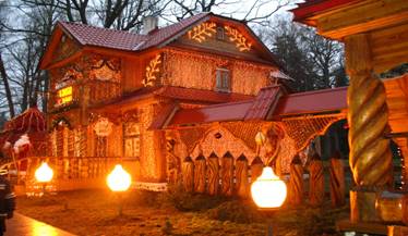
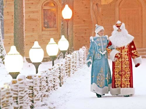
As a new tourist attraction, the forest features the residence of Grandfather Frost, known as Ded Moroz, the Eastern Slavic Santa Claus, that works all the year round.
Belaya Vezha
Within half an hour ride from the national park of Belovezhskaya Pushcha, in the town of Kamenets, there is an old tower of the 13th
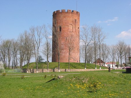 century. The tower named Belaya Vezha was erected by architect Alex (Oleksa) in 1271-1289 and now is protected by the state as a memorial site. Initially the tower was supposed to serve as a frontier post on the western border of ancient Russia. The tower was restored in 1903 according to the project of Russian architect V. Suslov.
 Five-storied building with height of 29.4 m (96.5 ft) possesses outer diameter of 13.6 m (44.6 ft) and walls with width of 2.5 m (8.2 ft). Total area of floors equals to 300 sq.meters (3230 sq.ft). In the walls of the tower built of hardened bricks there are vaulted windows serving as loop-holes. On the top of the tower there is a special fighting post circled with 14 merlons with narrow view slits. At first glance Belaya Vezha is quite simple however due to its good position on the hill, very compact forms and laconic architectural details it is highly impressive. The branch of Brest ethnography museum has been housed in the tower since 1960.
Brest lies astride the Mukhavets River, that is known to Bresters as "the river". The river flows west through the city, dividing it into north and south, and meets the Western Bug in the Brest Fortress. The river flows slowly and gently
 . You can hop into a tube that looks like a big rubber doughnut and take a relaxing float down this river. Today the river looks quite broad in Brest. The terrain is fairly flat around Brest. The river has an extremely broad floodplain, that is about 2–3 km across. Brest was subject to flooding in the past. One of the worst floods in recorded history occurred in 1974.
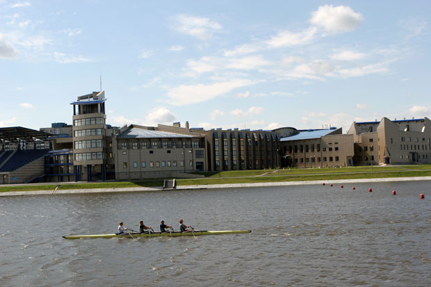
 Rowing course in Brest
A part of the floodplain was reclaimed from the river during the last 3 decades. In the 1980s big cutter-suction dredgers were mining sand and clay from the riverb
 ed, to raise the banks. After the dredging the river became deeper and the riverbanks higher. Today the river does not overflow its banks.
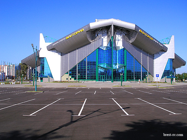
 the largest stadium in Brest
In the 2000s Brest developed new residential areas and sports attractions on the reclaimed land along the river and increased its vitality. The big sports venues on the northern riverside are an indoor track-and-field center, the Ice Palace (Ice Arena) and Belarus' first ever outdoor baseball stadium. On the opposite riverside is a large rowing course opened in 2007, home to the National Center for Olympic Training in Rowing. It meets international requirements and can host international competitions. It has accommodation and training facilities, favorable location, 3 km away from the border crossing along Warsaw Highway (the European route E30). Sights around Brest